• Skip to primary navigation
  • Skip to main content

Digital and Computational Studies Blog

Bowdoin College - Brunswick, Maine

  • Home
  • Research Opportunities
  • Courses
  • Events
  • Faculty and Staff
  • About the DCS Blog
  • Show Search
Hide Search

Gabriella Papper '18

Origin of Digital and Computational Studies at Bowdoin

May 20, 2016 By Gabriella Papper '18

Assembled by Crystal Hall, Associate Professor of Digital Humanities, Co-Director of DCS 2015- and Gabriella Papper ’18, DCS Teaching Assistant, Research Assistant, and course alumna

Digital and Computational Studies began in Fall 2012 after a meeting of the Bowdoin College Board of Trustees. Several faculty members from multiple disciplines joined a steering committee charged with this curricular initiative. Through a series of satellite meetings with colleagues from the humanities, social sciences, and physical sciences, they discussed the place of computation and digital disruption in a liberal arts environment. With the steering committee’s guidance, 2012-2013 marked the inaugural year of the “Computation and the Liberal Arts Colloquium,” which included events representing the fields of art history, biology, classics, computer science, mathematics and visual arts. In Spring 2013 co-directors Eric Chown and Pamela Fletcher announced the first DCS course: “Gateway to the Digital Humanities.” A student assistant for the course developed the first version of the DCS logo, which has undergone at least three iterations in the intervening years.

DHWiki logo DCSlogo2015


By Fall 2014 there were five courses on the books, including three that were part of the Digital Humanities Course Cluster, a Mellon Humanities Initiative. Thanks to tremendous faculty and student support, in 2014-2015 DCS was able to move beyond just the humanities to connect students across disciplines through computational thinking, data analysis, critical interrogation and design of digital resources, and the understanding of the ways that technological changes are impacting everyday life. Former Bowdoin College President Barry Mills ’72 summarized this change in one of his departing reflections on the College: “So, what’s different about Bowdoin’s approach? Unlike other colleges and universities, at Bowdoin we are incorporating this mode of inquiry throughout the disciplines.”

President Mills concluded that piece by saying: “This isn’t about being  “relevant”; it is about educating our students to be informed, thoughtful citizens who can lead their communities—the age-old purpose of the liberal arts.” Incoming President Clayton Rose, asked many questions on this theme in his Opening of the College remarks at Convocation in Fall 2015: “What should a Bowdoin liberal arts curriculum be in five years, for the next 10-15? In particular, what will it mean to be “liberally educated” at Bowdoin in the future? What is great teaching? What is profound learning? What makes both possible? What roles should athletic, cultural, service, and other experiences play in complementing the intellectual engagement here? What role should technology play in both what we teach and how we teach?”

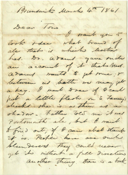
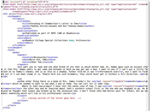
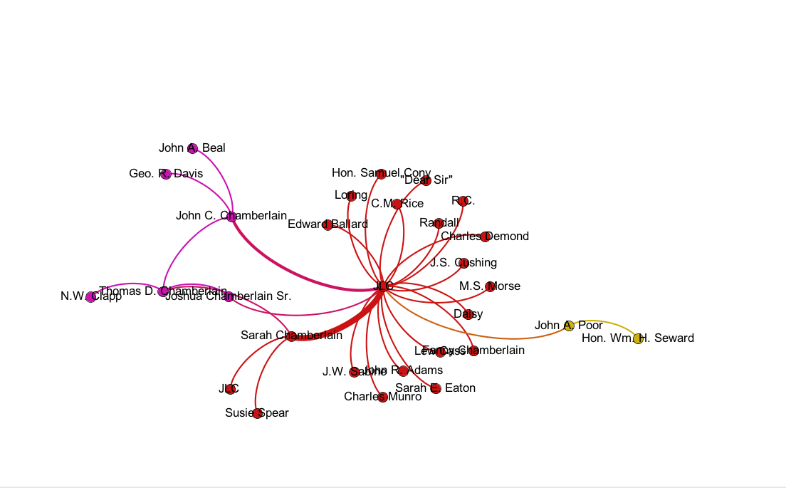
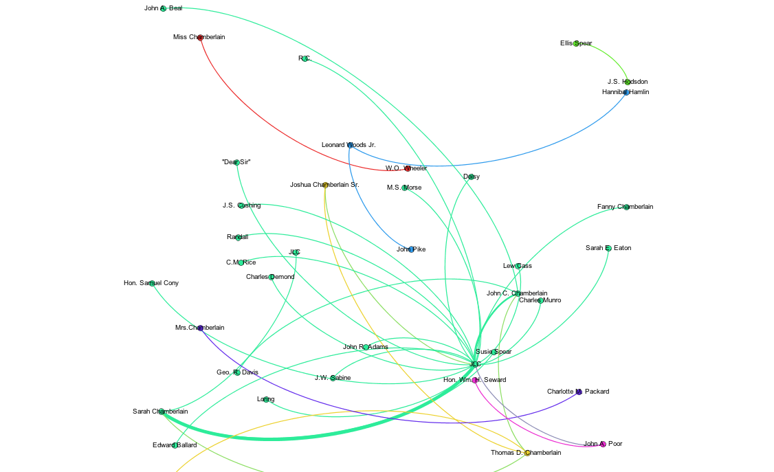
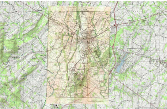
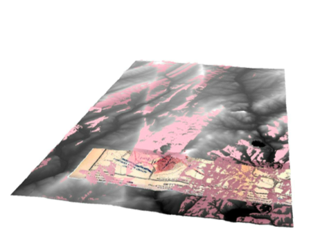
The faculty members and steering committee for DCS had been investigating these questions throughout the 2014-2015 academic year while developing a more expansive introductory course for this new field of study. DCS 1100 marked a new beginning for the program: an articulation of a core suite of tools and topics. Students worked with computation in Python, spatial analysis with ArcGIS, network analysis with Gephi, and structured markup of data with XML. Topics for readings and projects primarily addressed the theme of what it means to study an individual using digital resources. The course is oversubscribed for Fall 2016.

We invite you to explore the other courses and events that have been offered as part of DCS!


Tool: XML

April 15, 2016 By Gabriella Papper '18

XML stands for EXtensible Markup Language. It is a language like HTML that allows you to markup your data. You can use XML to markup a letter, documents or other forms of data. One of the most prominent XML editors is called oXygen, which has XML development tools for people with all different skill levels. XML, however, does not have predefined tags. This means that the user decides what the tags are and how the document is going to be structured.

One benefit of XML is that it conveys less tangible information that accompanies data. For example, with a letter, XML enables you to tag areas of the letter that were damaged or areas that had notes in the margins. By using XML, you preserve the information found in physical documents. You can tag your text based on content and/or structure. If you did not use XML and simply accepted the text as data from a machine, you would lose the context of the document.

Data is stored in plain text format in XML. This makes it easier to share data, preserve data, and understand data. The standard markup format in XML is <tag> TEXT </tag>.

Screen Shot 2015-11-17 at 11.09.07 AM             Screen Shot 2015-11-17 at 11.09.15 AM

Original Joshua Chamberlain letter (left) that was then decoded and transcribed in an oXygen file (right). Credit: Ana Timoney-Gomez (created for Introduction to Digital and Computational Studies, Fall 2015).


DCS Courses Fall 2016

April 5, 2016 By Gabriella Papper '18

Three Digital and Computational Studies courses will be offered in Fall 2016. More information on these courses can be found under the Digital and Computational Studies subject category on Polaris. Each course is interdisciplinary and students will learn both technical and analytical skills.


DCS 1100: Introduction to Digital and Computational Studies

Professor Mohammad Irfan and Professor Crystal Hall

Distribution Requirement: MCSR

How are digital tools and computational methods being applied and studied in different fields? How are they catalyzing changes in daily life? Uses two case studies to introduce these new tools and methods, and to analyze and evaluate their scholarly and practical applications. The first case study is based on Bowdoin’s own history: how can the use of new methods recreate what Joshua Chamberlain could see at the Battle of Gettysburg, and thus better understand the battle and his decisions? Next, considers the contemporary, and asks what is identity in the era of social media and algorithms? Students learn the basics of the Python programming language, introductory spatial analysis with ArcGIS, elementary text and social network analysis, and basic environmental modeling. Assumes no prior knowledge of a programming language.

This course has a separate lab.

Fields represented include:

English, History, Environmental Studies, Biology, Government, Sociology, Mathematics

Scroll through the examples below to see the kinds of projects Introduction to Digital and Computational Studies students completed in Fall 2015:

Screen Shot 2015-11-17 at 11.09.07 AM             Screen Shot 2015-11-17 at 11.09.15 AM

Original Joshua Chamberlain letter (left) that was then decoded and transcribed in an oXygen file (right). Credit: Ana Timoney-Gomez (created for Introduction to Digital and Computational Studies, Fall 2015).

CivilWar2 CivilWar1

Joshua Chamberlain’s correspondence network, based on original letters, is visualized in Gephi.

Screen Shot 2015-11-17 at 10.52.26 AM

ArcGIS Map of Present Day Topo Map and Historical Map of Gettysburg layered on top. Credit: Ana Timoney-Gomez (created for Introduction to Digital and Computational Studies, Fall 2015).

Screen Shot 2015-11-17 at 10.55.59 AM

ArcGIS 3-D image model. The pink color shows what Joshua Chamberlain was able to see at Gettysburg. Credit: Ana Timoney-Gomez (created for Introduction to Digital and Computational Studies, Fall 2015).

DCS 2020: Forecasting and Predictions

Instructor: Michael Kowal

There are few human endeavors as important as making good predictions. Being able to make good predictions is central to effective decision making. Computers and the internet have enabled an explosion in the prediction market where everyone from political consultants to large corporations rely on an ever increasing amount of data to make the predictions that drive their decision making. This course looks at the topic of predictions through the lens of how it is currently impacting our world. By understanding how predictions are made we can better understand how the actors shaping our world are making their decisions. In the Fall of 2016, for example, the focus of the course will be on the Presidential election and will examine questions such as how data analysts forecast the election and how those forecasts in turn are used to alter the behavior of the candidates. Students will learn the techniques used to make predictions and how to asses the quality of those predictions.

Fields represented include:

Government, Computer Science, Mathematics

Tool: GIS

March 25, 2016 By Gabriella Papper '18

ArcGIS is a software program that scholars and researchers in many disciplines use to produce and analyze geospatial data. GIS stands for geographic information system. Spatial analysis is a way to gather information on the locations and features of spatial data. Digital humanists can use spatial analysis to help answer questions about location and visualization.

ArcGIS offers many tools in order to examine spatial data.

Georeferencing puts data into a spatial context. This means that an image can be assigned real-world coordinates. For example, one project georeferenced old maps. Before georeferencing, these maps existed without spatial context or a coordinate system. These old maps were then referenced to modern maps using control points that were found on both maps. Referencing using control points enabled the old maps to become digital representations of a physical space. Georeferencing can also indicate the accuracy of older images.

Screen Shot 2015-11-17 at 10.52.26 AM

ArcGIS Map of Present Day Topo Map and Historical Map of Gettysburg layered on top. Credit: Ana Timoney-Gomez (created for Introduction to Digital and Computational Studies, Fall 2015).

The georeferenced version of the map was adjusted according to control points from a modern topo map. The distortion of the georeferenced map shows that the original map did not have the same spatial context or coordinate system as the modern map. Georeferencing encourages us to look at the details and distinct features found on maps.

Geoprocessing is a tool that enables you to manipulate spatial data, which means that your input data will look different from your output data. Geoprocessing focuses on the features of the input image, such as visibility and terrain.

ArcGIS (and ArcScene) can now also perform 3-D image modelling.

Screen Shot 2015-11-17 at 10.55.59 AM

ArcGIS 3-D image model. The pink color shows what Joshua Chamberlain was able to see at Gettysburg. Credit: Ana Timoney-Gomez (created for Introduction to Digital and Computational Studies, Fall 2015).


Although GIS is an helpful tool if you are working with environmental data, it is also extremely useful in many other areas (mapping, census data, business, health, migration, etc.). ArcGIS now also offers a collaborative web version that allows you to share content and project layers.

Further Reading: The Spatial Humanities: GIS and the Future of Humanities Scholarship edited by David J. Bodenhamer, John Corrigan, Trevor M. Harris.


DCSI Event on Campus: “Big Data Insights for Political Campaigns and Elections”

February 11, 2016 By Gabriella Papper '18

Next week, James Gimpel, professor of government at the University of Maryland, College Park, will discuss his research into big data, political campaigns, and voter attitudes.

“Big Data Insights for Political Campaigns and Elections”

Monday, February 15th | 7 p.m.
Location: Beam Classroom, VAC
Open to the public
Sponsored by the Bowdoin Departments of Government and Digital and Computational Studies

Political campaigns are now using big data to get information on voters’ attitudes and behaviors. Big data can be used to microtarget voters before elections and help campaign fundraising as well as influence other areas of elections. Professor Gimpel’s research focuses on political behavior, campaigns and elections, public opinion and immigration politics and policy. Interested students can also have dinner with Professor Gimpel at 5:30 in Thorne before the lecture.

  • Go to page 1
  • Go to page 2
  • Go to Next Page »

Digital and Computational Studies Blog

research.bowdoin.edu